 نقشه فقر و مشکلات آن
مریم امیری
Maryam Amiri, Tehran Community Manager
طرح ارتقای سکونتگاههای غیررسمی در ایران برای نخستین بار در سال 1378 با همکاری بانک جهانی کلید زده شد. از آن زمان تاکنون در دهها شهر کشور طرح مشابهی تهیه و اجرا شده است.
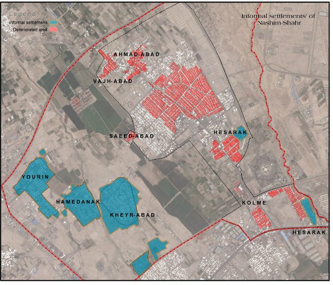
اولین قدم در تهیه این طرح ها، تعیین محدوده سکونتگاه غیررسمی است. برای این منظور معیارهای مشخصی توسط دولت (شرکت عمران و بهسازی شهری) با همکاری شهرسازان مشاور تعریف شده است که با توجه به ویژگی های منحصر به فرد هر شهر میتوان معیارهای دیگر نیز به آن ها افزود.
به عنوان مثال برخی از این معیارها عبارتند از:
فقدان سند رسمی ملک که فراگیرترین معیار تشخیص سکونگاه غیررسمی است
پایین بودن درآمد خانوار نسبت به متوسط شهر
فقدان تسهیلات بهداشتی مانند حمام و توالت و یا ناکافی بودن آنها
عدم بهره مندی از زیرساختهایی مانند آب و برق به صورت قانونی
رواج مشاغل غیررسمی
بالا بودن تراکم جمعیتی
بالا بودن میزان جرم و جنایت و اعتیاد
برای جمع آوری اطلاعات، از تکنیک های مختلفی استفاده میشود. مصاحبه، پرسشنامه و برداشت کالبدی از مهمترین روشها هستند. پس از بررسی محله، داده های خام با استفاده از نرم افزار GIS تحلیل میشود. نتیجه این تحلیل تعیین مکان فقر زده ترین بخش شهر و سکونتگاههای غیررسمی است. گام بعدی طرح توانمندسازی سکونتگاههای غیررسمی، مطالعه عمیق تر مسائل و راه حل های بالقوه حل مسائل در این مناطق است. برای این منظور به طور گسترده از مسئولان کلیدی شهر و ساکنان سکونتگاهها نظرخواهی میشود.
اما انتقادات زیادی به طرح های توانمندسازی که در ایران تهیه و اجرا میشود وارد است. اول اینکه دولت معمولا برای تهیه طرح های ارتقای سکونتگاههای غیررسمی بودجه کافی اختصاص نمی¬دهد و شرکت های مشاور شهرسازی به سختی می¬توانند هزینه های برداشت و تحلیل اطلاعات را تامین کنند. همین باعث میشود کیفیت جمع آوری اطلاعات و تحلیل داده ها پایین باشد. مشکل دیگر دیدگاه امنیتی مسئولان شهری است که باعث میشود از ارائه اطلاعات به مشاور سرباز بزنند. به ویژه به دلیل سابقه شورش های شهری در سکونتگاههای غیررسمی، آنها واهمه دارند که انتشار اطلاعات مربوط به فقر شهری، ساکنان را برای شورش های دیگر تشویق کند.
از سوی دیگر، طرح های توانمندسازی به طور موازی با طرح های «بهسازی بافت فرسوده» پیش میرود. در حالی که معیارهای که در ابتدا به آن ها اشاره کردیم در هر دو مورد تقریبا یکسان است. در نتیجه ممکن است در یک شهر، یک منطقه به عنوان سکونتگاه غیررسمی شناخته شود و منطقه مجاور آن به عنوان بافت فرسوده. در حالی که ساکنان هر دو منطقه از مسائل یکسانی در رنج هستند. اشکال مهم این امر این است که ساکنان به طور یکسان از این طرح ها منتفع نمیشوند. غالبا نتیجه نهایی طرح توانمدسازی سکونتگاههای غیررسمی، پروژه های کم هزینه ای است که تاثیر چشمگیری بر تغییر شرایط زندگی ساکنان ندارد. در حالی که به ساکنان «بافت فرسوده» وام دولتی و تخفیف در عوارض ساختمانی تعلق می¬گیرد.
علیرغم این انتقادات، نقشه ای کردن فقر و مستندسازی شرایط زیستی ساکنان سکونتگاههای غیررسمی، گام مهمی برای بهبود وضعیت آنهاست. اولین قدم برای حل یک مسئله شناسایی آن است.
Photo: Farmitan Consulting Engineers
Permalink to this discussion: http://urb.im/c1503
Permalink to this post: http://urb.im/ca1503tep
Poverty mapping and its difficulties
Maryam Amiri, Tehran Community Manager
Tehran, 16 March 2015
The "informal settlement upgrading plan" was started in Iran for the first time in 1999 through a mutual cooperation between the World Bank and the Iranian government. Since then, a similar plan has been executed in dozens of Iranian cities.
The initial stage in performing an upgrading plan is to identify the affected regions by defining the geographical boundaries of each informal settlement. To do this, the government's Urban Development and Revitalization Organization and an advisory board of urban planners have developed certain criteria to distinguish informal settlements from other parts of a city. Although the criteria are the same for all Iranian cities, they can include more specific criteria for each city.
Some of the parameters and the criteria are:
- Lack of formal title registries among the residents
- Lower-than-average household income
- Lack of sanitary facilities like baths and toilets
- Invalidity of legal infrastructures like electricity and water
- Prevalence of informal employment
- High rates of crime and drug abuse
A wide range of neighborhood survey techniques are used to collect the basic information, including the personal interview, questionnaire, residents' surveys, non-resident surveys, and environmental surveys. Upon completion of this phase, the collected data is analyzed using the ArcGIS software; results of the analysis show informal settlements where the poorest households live. Furthermore, deeper studies assess the most critical problems in these areas in order to properly address them. To this end, city managers get involved and are asked to share their ideas about the settlement's visions.
This upgrading plan has been criticized for a number of different reasons. The government's payments to the private research companies are often inadequate for covering the costs of high-quality analysis, resulting in low-quality results. Some areas with a great majority of poor households are routinely missing among the results. Budgetary limitations are not the only problem: some local governors consider poverty mapping as a security issue and refuse to provide the basic information to the urban planners. This reluctance may be related to several recent revolts in informal settlements and the fear of future revolts.
Often, a similar plan for the "rehabilitation of deteriorated urban textures" is executed by the municipalities, and goes alongside the upgrading plan. The criteria for the latter are almost the same as the former, so one can often find two similar adjacent areas — one of which has been recognized as "informal settlement" and the other as a "deteriorated urban texture," although of course both are dealing with the same problems. Despite the similarities in the issues, the advantages for the residents are not equal: while upgrading projects are normally low-cost and hardly improve living conditions, residents living in rehabilitation zones are able to use low-interest loans and discounted construction permits.
Despite the inadequacies and criticisms mentioned above, visualizing and mapping poverty and living conditions is a significant step towards improving the situation of Tehran's poorest residents. Recognizing the problem is the first step to solving it.
Photo: Farmitan Consulting Engineers
Permalink to this discussion: http://urb.im/c1503
Permalink to this post: http://urb.im/ca1503tep